Interactive Map Canvas & Anchor Watch Guide
Master SpotLocker's vector map engine, depth contour overlay, structure filtering, real-time Kalman GPS smoothing, and emergency anchor watch.
1. Interactive Map Engine & Layers
The core navigation screen in SpotLocker ([`waypoint_map_screen.dart`](file:///d:/prfndr/spotlocker/flutter_app/lib/screens/waypoint_map_screen.dart)) renders high-resolution OpenStreetMap and MapLibre vector tiles customized for aquatic environments.
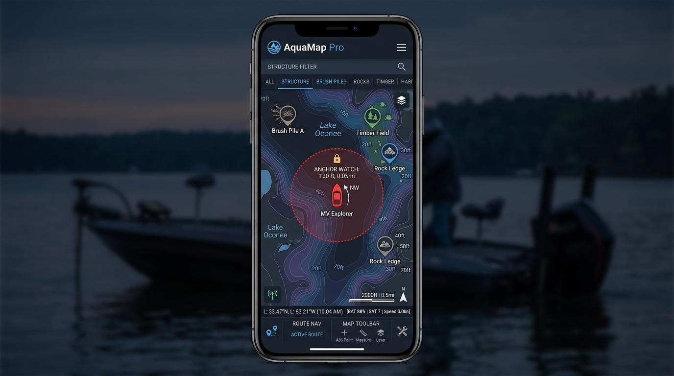
Map Layer Controls
- Depth Contours: High-density depth bathymetry lines displayed in feet or meters with color-coded shallow and deep water shading.
- Structure Icons: Distinct visual markers categorized into Brush Piles, Rock Ledges, Submerged Timber, Drop-Offs, Humps, and Buoys.
- Target Species Tags: Color-coded species badges (e.g., Largemouth Bass, Walleye, Crappie, Striped Bass).
2. Structure & Species Filtering
SpotLocker allows anglers to filter thousands of waypoints on the fly to find exact pattern structures for current weather conditions.
Brush Piles & Habitat
Filters man-made brush attractors and stake beds ideal for seasonal crappie and bass sanctuary.
Rock Ledges & Bluffs
Pinpoints steep underwater drop-offs and river channel ledges where predator fish stack up.
Standing Timber
Highlights flooded forest timber fields and creek channel crossings.
Submerged Humps
Isolates offshore humps and shoals rising out of deep open water.
To apply a filter, tap the Structure Filter Bar at the top of the map screen and select one or more categories.
3. High-Speed Kalman GPS Position Smoothing
Standard mobile phone GPS chips often suffer from satellite jitter, position jumps, and erratic heading spins when travelling at high speeds or under heavy tree canopy along shoreline bluffs.
SpotLocker processes raw NMEA/GPS location updates through a 2D linear Kalman filter algorithm. The filter measures covariance, velocity vectors, and acceleration dynamics to produce a smooth, lag-free vessel position indicator on the map canvas even at speeds exceeding 50 knots.
4. Setting Up Anchor Alarm & Drift Watch
When fishing overnight or holding over offshore structure in heavy wind or current, SpotLocker's Anchor Watch service ([`anchor_alarm_service.dart`](file:///d:/prfndr/spotlocker/flutter_app/lib/services/anchor_alarm_service.dart)) monitors vessel drift relative to your dropped anchor point.
Drop Anchor Reference Point
Tap the Anchor Watch icon on the map action bar. SpotLocker instantly captures your current GPS coordinates as the anchor point center.
Set Allowed Drift Radius
Adjust the slider to set your safe radius boundary (e.g., 50 ft, 100 ft, 200 ft) depending on scope depth and rode length.
Active Monitoring & Audio Alarm
A red dotted geofence ring renders around your boat. If your vessel drifts outside the boundary, SpotLocker sounds a loud 95dB alarm tone, vibrates the device, and broadcasts a voice warning via Nautical Audio.